
Showing posts with label Kalk Bay mts. Show all posts
Showing posts with label Kalk Bay mts. Show all posts
Maidens Peak and Kalk Bay Peak
Down to the Sunbird Centre

Meet at the Wolfkop Carpark (off Ou Kaapse Weg) and we will walk around Maiden Peak and Klein Tuinkop via the Amphitheatre and then turn down towards the Sunbird Centre where a car will be waiting to take us back.
Probably about 3 to 4 hours long.
Thirty-first Anniversary Walk that never happened Walk
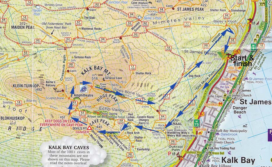 Meet at Westray Steps/Ou Kraal path on Boyes Drive.
Up Echo Valley, then on the Jojolou Track round Cave Peak (dogs on leads!) and through the amphitheatre and round the back to join the Spes Bona Forest path. We can return the same way or the slightly longer - and more scenic - route past Dog Rock. (Though have never worked out which rock is Dog Rock!)
Three to four hours.
April Fool Walk to Spes Bona Forest
 We are meeting on Boyes Drives at the Ou Kraal path near Westray Steps at 7.30 to go and look for the April Fool flowers in Spes Bona Forest.
  Two years ago these Haemanthus coccineus flowers were spectacular but that is not always the case. In his book Table Mountain Walks, Colin Paterson-Jones writes, "In the Spes Bona Forest there is a large population of Haemanthus coccineus (April fool flowers); their pairs of broad, strap-shaped leaves (lying flat on the ground) carpet the forest floor. This population of plants never flowers but reproduces vegetatively. Clearly the spot where they grow was, some time in the past, not covered by trees."
But these photos prove that they do sometimes flower! Will we be lucky this year?

Up Pecks via St James Peak and back

 Meet at the stone entrance to Pecks Valley on Boyes Drive - overlooking Muizenberg. Should take about 2 hours max.
Klein Tuinkop Walk
 Meet at the Wolfkop Parking on Silvermine east side - on left as you come up the pass on Ou Kaapse Weg.
A good 3 hours (add on another hour for photographs).
Trappieskop Stappie

 Meet at the start of the path on Clovelly Rd, Clovelly - just before Dunvegan Lodge.
Estimated time: 2-3 hours depending on tea and flowers ...
A snippet of information about Trappieskop from the Mountain Club's website:
How did Trappieskop above Kalk Bay get its name?
Trappieskop is a small peak overlooking Kalk Bay.The upper layers of this peak are made outof high quality Table Mountain sandstone which provide some excellent sport climbing routes.
Unknown to most Capetonians is that there are several stone age archaeological sites which were partly excavated in 1945 by Mr Peers and his son. This father and son pair investigated and catalogued many sites in the Southern Peninsula and were responsible for the excavation of Peers’ Cave (Skildergat Cave).
At the 30m level above sea level there is clear evidence of horizontal beach accumulations. What will global warming alarmists have to say about this irrefutable proof that changes in climate, sea levels have been around for thousands of years?
Other than sports climbing there is a wonderful walk around the peak. The best place to start on the traverse of the peak on the fire break is at Behr Road, Quarry Road, Godfrey Road, Marmion Avenue or at the sharp corner on Clovelly Road just before the Clovelly Golf Course. The scenic walk is not taxing and in spring time has a wealth of flowering plants.
In early times it was at first virtually impossible to travel along the coast from Muizenberg to Fish Hoek and on to Simon’s Town because in places the mountains reached all the way down to the sea. The old wagon road – die ou wapad – die ou Kaapse weg went up the Steenberg mountain and over the top of the mountains to Fish Hoek and over Brakkloofrand (now also known as Black Hill) on to Simon’s Town. The present and much more recent motor road of the same name does not quite follow the same route.
Because of necessity (development of Simonstown as a winter shelter for shipping) the passable track along the coast at the foot of the mountains was eventually developed into a wagon friendly route when explosives arrived in the colony. Approaching Fish Hoek beach there was a series of ledges, which were likened to steps that traffic had to negotiate before the track continued along Fish Hoek beach. The beach had to be utilised because the remainder of the area consisted of sand dunes and was not traversable.
Before these steep, zig-zag ledges were adjusted enough to be used by animal drawn vehicles they were suitable only for pedestrians though it would appear that daring cart drivers could manage them. Fishermen first called the shortcut die trap reis – the steps journey, but as years passed the area became known simply as die trappies and the hill at whose foot it lay, die trappies kop.
Kalk Bay Jojolou Track
The Right Way Walk  Probably take us the best part of 5 hours depending on flowers.
(For example, the April Fool flowers in Spes Bona.)
Probably take us the best part of 5 hours depending on flowers.(For example, the April Fool flowers in Spes Bona.)
Boyes Drive to Ou Kaapse Weg via Spes Bona Forest

Estimated time: 3 hours.
Click on the image to enlarge
Subscribe to:
Posts (Atom)